Wind Chill Calculator
Calculate wind chill from air temperature and wind speed with the NWS and Environment Canada formula, in °F and mph or °C and km/h, with frostbite risk.
Calculator
At or below 50 °F (10 °C).
The forecast wind, measured at 33 ft (10 m). Above 3 mph (4.8 km/h).
Working, with your numbers
- WCT = 35.74 + 0.6215 x T - 35.75 x V^0.16 + 0.4275 x T x V^0.16, in °F and mph
- T = 10 °F (-12.22 °C), V = 20 mph (32.19 km/h), V^0.16 = 1.615
- = 35.74 + 0.6215 x 10 - 35.75 x 1.615 + 0.4275 x 10 x 1.615
- = 35.74 + 6.215 - 57.74 + 6.904
- = -8.876 °F (-22.71 °C)
Values are converted into the units the equation is worked in before the arithmetic.
- As a forecast gives it Each service rounds its own formula to a whole degree: the NWS’s in °F, Environment Canada’s in °C.
- −9 °F, −23 °C
- Environment Canada’s formula W = 13.12 + 0.6215 T − 11.37 V^0.16 + 0.3965 T V^0.16, with T in °C and V in km/h, which Environment Canada uses at or below 0 °C with a wind of 5 km/h or more. Its coefficients were rounded separately from the °F form’s, so the two can differ by a few hundredths of a degree.
- −22.7 °C
- Frostbite risk (Environment Canada) Environment Canada’s levels, by the wind chill in whole °C: Low 0 to −9, Moderate −10 to −27, High −28 to −39, Very high −40 to −47, Severe −48 to −54, Extreme −55 or colder.
- Moderate risk: risk of hypothermia and frostbite if outdoors for long periods of time without adequate protection
Citing this tool
Last updated . Add the date you accessed it as well, which a citation of a page that can change asks for. If a specific result matters, cite the permalink from the tool’s share row instead of this page: it reproduces the exact parameters.
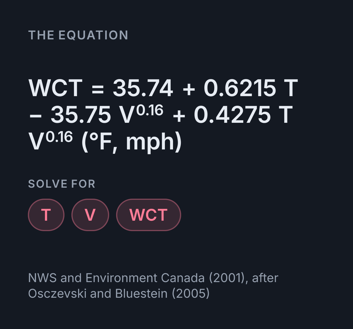
The equation
NWS and Environment Canada (2001), after Osczevski and Bluestein (2005)
What is the wind chill formula?
The US National Weather Service wind chill formula is WCT = 35.74 + 0.6215T − 35.75V0.16 + 0.4275TV0.16, with air temperature T in °F and wind speed V in mph. It holds only at or below 50 °F and above 3 mph. Environment Canada’s metric form is W = 13.12 + 0.6215T − 11.37V0.16 + 0.3965TV0.16, in °C and km/h.
What the number means
A wind chill is the temperature of calm air that would cool a bare face as fast as the actual wind and air do. Environment Canada’s own illustration: at −10 °C with a wind chill of −20, your face feels about as cold as it would on a calm day at −20 °C. The NWS and Environment Canada adopted the index in 2001, and Osczevski and Bluestein (2005) describe the model of facial heat loss behind it. The NWS lists its other assumptions: a consistent standard for the resistance of skin tissue to heat, and no sun, as under a clear night sky.
The wind it asks for is the wind at 33 ft (10 m), the standard height of an anemometer and the speed a forecast or a weather station quotes. The model itself brings that wind down to about 5 ft, the height of an adult face. Wind slows toward the ground, so a handheld meter read at face height usually shows less than the forecast wind, and putting that reading in gives a wind chill that is too warm.
The wind enters as its 0.16 power, so each extra mile per hour lowers the wind chill less than the one before, and the same wind takes more degrees off a cold day than a mild one: a 20 mph wind takes 12.6 °F off 30 °F air but 25.1 °F off −10 °F air. The calculator solves for the air temperature or the wind as well, and the readouts give Environment Canada’s value in °C beside the NWS answer.
Why it stops at 50 °F and 3 mph
The NWS defines wind chill only for those conditions, and the calculator refuses anything outside them rather than extrapolate. The formula still returns numbers there, but they stop meaning anything: at 60 °F in a 4 mph wind it gives 60.4 °F, a wind chill warmer than the air. Below 3 mph the NWS treats the air as calm.
Environment Canada draws its limits differently. It reports wind chill only when the air is at or below 0 °C, and below 5 km/h it switches to a second formula for light winds, which this calculator does not use. Between 0 and 10 °C the °C figure here is therefore the formula’s value, not one a Canadian forecast would issue.
Wind chill and objects
In the NWS’s words, wind chill applies only to people and animals. Wind makes a car radiator or a water pipe cool to the air temperature faster, and the NWS says it will not cool below it. It also notes that the air itself has to be below freezing for frostbite to develop on exposed skin. So at 35 °F in a 20 mph wind the wind chill of 23.9 °F describes how fast a face loses heat, not a temperature anything reaches.
Humidity plays no part in the formula. It matters in hot weather, where the heat index calculator and the humidex calculator answer the opposite question, and the psychrometric chart explorer shows the moist air properties behind both.
Frostbite risk levels
| Wind chill, as Environment Canada prints it | In °F, rounded | Risk | What it says happens |
|---|---|---|---|
| 0 to −9 °C | 32 to 16 °F | Low | Slight increase in physical discomfort |
| −10 to −27 °C | 14 to −17 °F | Moderate | Risk of hypothermia and frostbite if outdoors for long periods of time without adequate protection |
| −28 to −39 °C | −18 to −38 °F | High | Any exposed skin can freeze in 10 to 30 minutes |
| −40 to −47 °C | −40 to −53 °F | Very high | Any exposed skin can freeze in 5 to 10 minutes |
| −48 to −54 °C | −54 to −65 °F | Severe | Exposed skin can freeze in 2 to 5 minutes |
| −55 °C or colder | −67 °F or colder | Extreme | Exposed skin can freeze in less than 2 minutes |
Environment Canada adds that in sustained winds over 50 km/h (31 mph), frostbite can occur faster than these times, and the calculator warns when that applies. The levels are a guide for planning time outdoors; follow local cold weather warnings where they are issued.
Common mistakes
- Typing km/h into the mph field. At −10 °C a 30 km/h wind gives a wind chill of −19.5 °C, but 30 entered as mph, which is 48 km/h, gives −21.6 °C. Pick the unit in the menu beside each field and the conversion is done for you.
- Converting a rounded °F value and expecting Environment Canada’s figure. Each service rounds its own formula to a whole degree, so a US forecast converted to °C can land a degree away from the Canadian one for the same air. Both are correct.
- Applying it in sunshine. The index assumes no sun. It says nothing about how much bright sunshine offsets the wind on a clear winter day.
Converting units first? Use the temperature and speed conversion tables.
How to calculate wind chill
- Write down the formula:
WCT = 35.74 + 0.6215 · T - 35.75 · V^0.16 + 0.4275 · T · V^0.16 (°F, mph) -
Gather the values it needs. The calculator above starts with these:
- Air temperature: T = 10 °F
- Wind speed: V = 20 mph
-
Substitute them and work through the arithmetic:
- WCT = 35.74 + 0.6215 x T - 35.75 x V^0.16 + 0.4275 x T x V^0.16, in °F and mph
- T = 10 °F (-12.22 °C), V = 20 mph (32.19 km/h), V^0.16 = 1.615
- = 35.74 + 0.6215 x 10 - 35.75 x 1.615 + 0.4275 x 10 x 1.615
- = 35.74 + 6.215 - 57.74 + 6.904
- = -8.876 °F (-22.71 °C)
-
To find one of the other values instead, rearrange the formula for it:
- Air temperature:
T = (WCT - 35.74 + 35.75 · V^0.16) ÷ (0.6215 + 0.4275 · V^0.16) - Wind speed:
V = [(WCT - 35.74 - 0.6215 · T) ÷ (0.4275 · T - 35.75)]^(1 ÷ 0.16)
- Air temperature:
Worked examples
Each one runs through the calculator above, so the arithmetic here is the arithmetic it does.
What is the wind chill at 0 °F with a 15 mph wind?
- WCT = 35.74 + 0.6215 x T - 35.75 x V^0.16 + 0.4275 x T x V^0.16, in °F and mph
- T = 0 °F (-17.78 °C), V = 15 mph (24.14 km/h), V^0.16 = 1.5423
- = 35.74 + 0.6215 x 0 - 35.75 x 1.5423 + 0.4275 x 0 x 1.5423
- = 35.74 + 0 - 55.14 + 0
- = -19.4 °F (-28.55 °C)
The National Weather Service’s own example, which it reports as −19 °F and at which it says exposed skin can freeze in 30 minutes. At exactly 0 °F both terms with T in them vanish, leaving 35.74 and the wind term.
What air temperature gives a wind chill of −40 in a 30 km/h wind?
- T = (WCT - 35.74 + 35.75 x V^0.16) / (0.6215 + 0.4275 x V^0.16), in °F and mph
- WCT = -40 °F (-40 °C), V = 18.64 mph (30 km/h), V^0.16 = 1.5969
- = (-40 - 35.74 + 35.75 x 1.5969) / (0.6215 + 0.4275 x 1.5969)
- = -18.65 / 1.304
- = -14.3 °F (-25.72 °C)
Solved for the air temperature, in metric units that the working converts to °F and mph and back. −40 is the one reading that is the same in °C and °F, and Environment Canada puts it in its very high risk level, where any exposed skin can freeze in 5 to 10 minutes.
What wind speed makes 20 °F feel like 0 °F?
- V^0.16 = (WCT - 35.74 - 0.6215 x T) / (0.4275 x T - 35.75), in °F and mph
- WCT = 0 °F (-17.78 °C), T = 20 °F (-6.667 °C)
- = (0 - 35.74 - 0.6215 x 20) / (0.4275 x 20 - 35.75)
- = (-48.17) / (-27.2) = 1.771
- V = 1.771^6.25
- = 35.59 mph (57.27 km/h)
Solved for the wind. It enters the formula as its 0.16 power, so each extra mile per hour does less than the one before: at 20 °F the first 5 mph bring the wind chill down to 13 °F, and it takes 35.6 mph to reach 0 °F.
Practise this with Thermodynamics Practice Problems, questions generated from this calculator and 13 other calculators in Thermodynamics.
Common questions
What is the wind chill formula in Celsius?
Environment Canada’s form is W = 13.12 + 0.6215T − 11.37V^0.16 + 0.3965TV^0.16, with T in °C and V in km/h. It is the NWS’s °F and mph formula with its coefficients converted and rounded separately, so the two agree within 0.06 °C from −50 to 10 °C and winds up to 100 km/h. At −20 °C in a 30 km/h wind it gives −32.6 °C, which Environment Canada reports as −33.
Why is wind chill only defined at or below 50 °F?
The NWS defines the index only at or below 50 °F (10 °C) and for winds above 3 mph, the cold and breezy weather its model of heat loss from the body was built for. Outside that range the formula still returns numbers, but they stop meaning anything: at 70 °F in a 5 mph wind it gives 71.7 °F, a wind chill warmer than the air. The calculator refuses those inputs rather than extrapolate.
At what wind chill can frostbite happen?
Environment Canada gives freezing times for exposed skin from a wind chill of −28 °C (about −18 °F): 10 to 30 minutes down to −39 °C, 5 to 10 minutes from −40 to −47 °C, 2 to 5 minutes from −48 to −54 °C, and less than 2 minutes at −55 °C (−67 °F) or colder, sooner in sustained winds over 50 km/h (31 mph). The NWS’s example, 0 °F in a 15 mph wind, gives −19 °F, at which it says exposed skin can freeze in 30 minutes. The air itself has to be below freezing for frostbite to develop.
Can wind chill freeze pipes or a car engine?
Not below the air temperature. The NWS says wind chill applies only to people and animals: wind makes an object such as a car radiator or a water pipe cool to the air temperature faster, but the object does not cool below the actual air temperature. A wind chill describes how fast exposed skin loses heat, not a temperature that anything reaches.
What wind speed should I use for wind chill?
The wind at 33 ft (10 m), the standard anemometer height and the speed a forecast or a weather station quotes. The model itself reduces that wind to its value at about 5 ft, the height of an adult face. A handheld meter read at face height usually shows less than the 33 ft wind, so entering its reading gives a wind chill that is too warm.
Why do wind chill values in °F and °C sometimes disagree?
Because each service rounds its own formula to a whole degree. At −10 °C (14 °F) in a 30 km/h (18.6 mph) wind, the NWS formula gives −3.1 °F, reported as −3 °F, which is −19.4 °C, while Environment Canada’s gives −19.5 °C, reported as −20. The two forms differ by less than 0.06 °C, but that can land a value on either side of a half degree. The calculator shows both.